Difference between revisions of "Unison:Global Address Verification"
(Created page with "{{UnisonNav |ServicesCollapse= }} {{CustomTOC}} The Unison by Melissa Global Address Cleansing Task cleanses global contact data. link= ==Input Fields== link= This section displays the possible inputs for the Address Service. An address and ZIP code are required. <h3 class="productfield">Organization</h3> :The company or organization. <h3 class="productfield">Address Line 1<...") |
m (Admin moved page Unison:Global Address Cleansing to Unison:Global Address Verification: Name Change) |
||
| (8 intermediate revisions by the same user not shown) | |||
| Line 8: | Line 8: | ||
The Unison by Melissa Global Address Cleansing Task cleanses global contact data. | The Unison by Melissa Global Address Cleansing Task cleanses global contact data. | ||
[[File:Unison_Address-Global_Task.png|link=]] | [[File:Unison_Address-Global_Task.png|900px|link=]] | ||
==Input Fields== | ==Input Fields== | ||
[[File:Unison_Address-Global_InputFields.png|link=]] | [[File:Unison_Address-Global_InputFields.png|900px|link=]] | ||
This section displays the possible inputs for the Address | This section displays the possible inputs for the Global Address Cleansing Task. An address and Country are required. | ||
<h3 class="productfield">Organization</h3> | <h3 class="productfield">Organization/Company</h3> | ||
:The company or organization. | :The company or organization. | ||
<h3 class="productfield">Address Line 1</h3> | <h3 class="productfield">Address Line 1</h3> | ||
:The first address line. | :The first address line. This should contain the delivery address information (house number, thoroughfare, building, suite, etc.) but should not contain locality information (locality, administrative area, postal code, etc.) which have their own inputs. | ||
<h3 class="productfield">Address Line 2 - Address Line 4</h3> | |||
:This is optional. This should contain the delivery address information (house number, thoroughfare, building, suite, etc.) but should not contain locality information (locality, administrative area, postal code, etc.) which have their own inputs. | |||
<h3 class="productfield">Sub-Premises/Suite</h3> | |||
:The sub-premises or suite number. | |||
<h3 class="productfield">Locality/City</h3> | |||
:The locality name. | |||
:'''US Term:''' City | |||
:'''Canada Term:''' Municipality | |||
<h3 class="productfield">Administrative Area/State</h3> | |||
:The administrative area, state or province name. | |||
<h3 class="productfield"> | <h3 class="productfield">Postal Code/Zip</h3> | ||
:The | :The Zip Code or Postal Code, depending on the country. | ||
<h3 class="productfield"> | <h3 class="productfield">Country</h3> | ||
: | :The country code. If this is not input, the country will default to the United States. | ||
<h3 class="productfield"> | ===More Input Fields=== | ||
: | [[File:Unison_Address-Global_InputFields-More.png|900px|link=]] | ||
<h3 class="productfield">Address Line 5 - Address Line 8</h3> | |||
:This is optional. This should contain the delivery address information (house number, thoroughfare, building, suite, etc.) but should not contain locality information (locality, administrative area, postal code, etc.) which have their own inputs. | |||
<h3 class="productfield">Country of Origin</h3> | |||
:This is used to determine whether or not to include the country name as the last line in Formatted Address. | |||
:*The destination country will be appended to the end of the formatted address when: | |||
::*Valid '''and''' different from the destination country. | |||
:*The destination country will '''not''' be appended to the end of the formatted address when: | |||
:''' | ::*Blank '''or''' | ||
::*Invalid '''or''' | |||
::*Same as the destination country | |||
<h3 class="productfield"> | <h3 class="productfield">Double Dependent Locality</h3> | ||
:The | :The smallest population center data element. This depends on the Locality and Dependent Locality fields. | ||
<h3 class="productfield"> | <h3 class="productfield">Dependent Locality/Urbanization</h3> | ||
:The | :The smaller population center data element. This depends on the Locality element. | ||
:'''US Term:''' Urbanization: In terms of US Addresses, this element applies only to Puerto Rican addresses. It is used to break ties when a ZIP Code™ is linked to multiple instances of the same address. | |||
<h3 class="productfield">Sub Administrative Area/County</h3> | |||
:The smallest geographic data element. | |||
:'''US Term:''' County. | |||
: | |||
= | <h3 class="productfield">Sub National Area</h3> | ||
:The administrative region within a country on an arbitrary level below that of the sovereign state. | |||
==Output Fields== | ==Output Fields== | ||
[[File:Unison_Address-Global_OutputFields.png|link=]] | [[File:Unison_Address-Global_OutputFields.png|900px|link=]] | ||
This section displays the possible outputs for the Address Service. Select the on/off toggle to enable/disable the output of a field. | This section displays the possible outputs for the Address Service. Select the on/off toggle to enable/disable the output of a field. | ||
| Line 71: | Line 102: | ||
<h3 class="productfield">Address Line 1</h3> | <h3 class="productfield">Address Line 1 - Address Line 8</h3> | ||
:The | :These will be the standardized or corrected contents of the input address. These lines will include the entire address including the locality, administrative area, and postal code. | ||
<h3 class="productfield">Zip/Postal Code</h3> | |||
:The postal code. | |||
:'''US Term:''' ZIP Code. | |||
<h3 class="productfield">Country</h3> | |||
:The country name. | |||
<h3 class="productfield">Latitude</h3> | |||
:The latitude of the address. | |||
<h3 class="productfield">Longitude</h3> | |||
:The longitude of the address. | |||
<h3 class="productfield">Dependent Locality</h3> | |||
:A dependent locality is a logical area unit that is smaller than a locality but larger than a double dependent locality or thoroughfare. It can often be associated with a neighborhood or sector. Great Britain is an example of a country that uses double dependent locality. In the United States, this would correspond to Urbanization, which is used only in Puerto Rico. | |||
:'''US Term:''' Urbanization. | |||
: | |||
<h3 class="productfield">Locality</h3> | <h3 class="productfield">Locality</h3> | ||
: | :The most common geographic area and used by virtually all countries. This is usually the value that is written on a mailing label and referred to by terms like City, Town, Postal Town, etc. | ||
:'''US Term:''' City | |||
<h3 class="productfield">Administrative Area/State</h3> | |||
:A common geographic area unit for larger countries. | |||
:'''US Term:''' State | |||
: | |||
<h3 class="productfield"> | <h3 class="productfield">Delivery Line</h3> | ||
:The | :The delivery portion of the full address, from the sub-premise and house number to the street information. This does not include area information like doubledependent locality, dependent locality, locality, administrative area, and postal code if those values are available for the country. | ||
<h3 class="productfield"> | <h3 class="productfield">Locality Line</h3> | ||
: | :The locality information of the full address. This includes information such as doubledependent locality, dependent locality, locality, administrative area, and postal code if those values are available for the country. This does not include sub-premise and house number to the thoroughfare information. | ||
<h3 class="productfield">Melissa Address Key</h3> | <h3 class="productfield">Melissa Address Key (MAK)</h3> | ||
:(MAK) A unique key assigned to an address record. | :(MAK) A unique key assigned to an address record. | ||
| Line 107: | Line 158: | ||
<h3 class="productfield">Address | <h3 class="productfield">Address Type Code</h3> | ||
: | :Returns a one-character code for the type of address coded. This element works only for US, Canadian, and Great Britain addresses. | ||
:See [[Result Code Details#Unison by Melissa|Unison by Melissa Result Codes]] for a full list of result codes. | |||
<h3 class="productfield">Formatted Address</h3> | |||
:Returns the address in the correct format for mailing from the country specified in the Country Of Origin input. This includes the Organization as the first line, one or more lines in the origin country’s format, and the destination country (if required). | |||
:The default separate line delimiter is a comma (<code>,</code>), but can be changed under the Address Task Settings. | |||
<h3 class="productfield">UPRN</h3> | |||
:'''Great Britain Only'''. Returns the Unique Property Reference Number created and maintained by Ordnance Survey. | |||
<h3 class="productfield">Result Codes</h3> | |||
:Returned result codes for the address. | |||
:For a list of result codes returned by Unison, see [[Result Code Details#Unison by Melissa|Unison Result Codes]]. | |||
: | |||
==Additional Address Fields== | |||
: | [[File:Unison_Address-Global_OutputFields-Additional.png|900px|link=]] | ||
Adds fields for parsed data from the address. | |||
<h3 class="productfield">ISO 2 Country Code</h3> | |||
:The 2 letter ISO 3166 country code value. | |||
:For example: | |||
: | |||
:{| class="alternate01" | |||
!Country !! Code | |||
|- | |||
|United States||US | |||
|- | |||
|Canada||CA | |||
|- | |||
|Philippines||PH | |||
|} | |||
<h3 class="productfield">ISO 3 Country Code</h3> | |||
:The 3 letter ISO 3166 country code value. | |||
:For example: | |||
: | |||
: | :{| class="alternate01" | ||
!Country !! Code | |||
|- | |||
|United States||USA | |||
|- | |||
|Canada||CAN | |||
|- | |||
|Philippines||PHL | |||
|} | |||
<h3 class="productfield">ISO Country Number</h3> | |||
:The ISO 3166 country number value. | |||
:For example: | |||
: | |||
:{| class="alternate01" | |||
!Country !! Code | |||
|- | |||
|United States||840 | |||
|- | |||
|Canada||124 | |||
|- | |||
|Philippines||608 | |||
|} | |||
<h3 class="productfield"> | <h3 class="productfield">Formal Country Name</h3> | ||
: | :Official Name for the country. | ||
==Parsed Dependent Thoroughfare Fields== | |||
: | [[File:Unison_Address-Global_OutputFields-ParsedDT.png|900px|link=]] | ||
Adds fields relating to the Dependent Thoroughfare from the address. | |||
<h3 class="productfield">Dependent Thoroughfare</h3> | |||
:The dependent thoroughfare is a second thoroughfare that is required to narrow down the final address. This is rarely used. | |||
<h3 class="productfield">Dependent Thoroughfare Pre Direction</h3> | |||
:Pre Directions are directionals at the beginning of the dependent thoroughfare (i.e., N, S, E, W, NE, SW, etc.). This is a part of the Dependent Thoroughfare field. | |||
<h3 class="productfield"> | <h3 class="productfield">Dependent Thoroughfare Post Direction</h3> | ||
: | :Post Directions are directionals at the end of the dependent thoroughfare (i.e., N, S, E, W, NE, SW, etc.). This value is a part of the Dependent Thoroughfare field. | ||
<h3 class="productfield"> | <h3 class="productfield">Dependent Thoroughfare Leading Type</h3> | ||
: | :Leading Types are types at the beginning of the dependent thoroughfare (i.e., "Rue", etc.). This value is a part of the Dependent Thoroughfare field. | ||
<h3 class="productfield"> | <h3 class="productfield">Dependent Thoroughfare Name</h3> | ||
:The | :The parsed Dependent Thoroughfare Name. This value is a part of the Dependent Thoroughfare field. | ||
<h3 class="productfield">Dependent | <h3 class="productfield">Dependent Thoroughfare Trailing Type</h3> | ||
: | :Trailing Types are types at the end of the dependent thoroughfare (i.e., "St.", "Rd.", "Ave.", etc.). This value is a part of the Dependent Thoroughfare field. | ||
<h3 class="productfield">Dependent Thoroughfare Type Attached</h3> | |||
:The dependent thoroughfare type connected to the dependent thoroughfare name without a space. This is common in Germany. For example, "Berlinerstr." "str." stands for strasse and is the dependent thoroughfare type attached, while "Berliner" is the dependent thoroughfare name. | |||
==Parsed Regional Fields== | |||
[[File:Unison_Address-Global_OutputFields-ParsedRF.png|900px|link=]] | |||
Adds additional fields relating to the region from the address. | |||
<h3 class="productfield"> | <h3 class="productfield">Double Dependent Locality</h3> | ||
: | :A logical area unit that is smaller than a dependent locality but bigger than a thoroughfare. This field is very rarely used. Great Britain is an example of a country that uses double dependent locality. | ||
<h3 class="productfield"> | <h3 class="productfield">Sub Administrative Area</h3> | ||
: | :A logical area that that is smaller than the administrative area but larger than a locality. While many countries can have a sub-administrative area value, it is very rarely used as part of an official address. | ||
<h3 class="productfield">Sub National Area</h3> | |||
:A logical area unit that is larger than an administrative area but smaller than the country itself. It is extremely rarely used. | |||
==Parsed Postal Facility Fields== | |||
[[File:Unison_Address-Global_OutputFields-ParsedPFF.png|900px|link=]] | |||
Adds additional fields relating to the postal facility. | |||
<h3 class="productfield"> | <h3 class="productfield">Post Box</h3> | ||
: | :The parsed Post Box. | ||
<h3 class="productfield"> | <h3 class="productfield">Post Office Location</h3> | ||
:This | :If available, this is the value that is associated to the location of the post office in relation to the address. This value may or may not be used in the official mailing address for the country in question. Currently, these are the countries we will return the data for: Serbia and Slovakia. | ||
:{| class="alternate01" | |||
!Country !! Description | |||
|- | |||
|Serbia||The Post Office Location field contains the old 5 digit postal number and name. The postal code field will contain the new 6 digit PAK number. | |||
|- | |||
|Slovakia||The Post Office Location field returns the name of the post office location if it is not the same as the delivery address locality. | |||
|} | |||
: | ==Parsed Thoroughfare Fields== | ||
[[File:Unison_Address-Global_OutputFields-ParsedTF.png|900px|link=]] | |||
Adds fields relating to the Thoroughfare from the address. | |||
<h3 class="productfield">Premises/Street Name</h3> | |||
:The parsed premises name. | |||
:'''US Term:''' Street Name | |||
<h3 class="productfield">Premises Number/Street Number</h3> | |||
:The parsed premises number. | |||
:'''US Term:''' House Number | |||
<h3 class="productfield">Premises Type</h3> | |||
:The parsed premises type. | |||
<h3 class="productfield">Thoroughfare</h3> | |||
:A part of the address lines containing all the sub-elements of the thoroughfare like trailing type, thoroughfare name, pre direction, post direction, etc. | |||
:'''US Term:''' Street | |||
: | |||
<h3 class="productfield"> | <h3 class="productfield">Thoroughfare Name</h3> | ||
:The | :The parsed thoroughfare name. This is part of the thoroughfare field. | ||
<h3 class="productfield">Thoroughfare Pre Direction</h3> | |||
:Pre Directions are directionals at the beginning of the thoroughfare (i.e., N, S, E, W, NE, SW, etc.). This is part of the thoroughfare field. | |||
<h3 class="productfield">Thoroughfare Post Direction</h3> | |||
:Post Directions are directionals at the end of the thoroughfare (i.e., N, S, E, W, NE, SW, etc.). This is part of the thoroughfare field. | |||
<h3 class="productfield">Thoroughfare Leading Type</h3> | |||
:Leading Types are thoroughfare types at the beginning of the thoroughfare (i.e., "Rue", etc.). This is part of the thoroughfare field. | |||
:This term is not used in the US. | |||
: | |||
<h3 class="productfield"> | <h3 class="productfield">Thoroughfare Trailing Type</h3> | ||
: | :Trailing Types are thoroughfare types at the end of the thoroughfare (i.e., "St.", "Rd.", "Ave.", etc.). This is part of the thoroughfare field. | ||
<h3 class="productfield"> | <h3 class="productfield">Thoroughfare Type Attached</h3> | ||
:The | :The thoroughfare type connected to the thoroughfare name without a space. This is common in Germany. For example, "Berlinerstr." "str." stands for strasse and is the thoroughfare type attached, while "Berliner" is the thoroughfare name. | ||
==Parsed Subpremises Fields== | |||
[[File:Unison_Address-Global_OutputFields-ParsedSF.png|900px|link=]] | |||
Adds fields relating to the sub premises from the address. | |||
<h3 class="productfield">Building</h3> | |||
:Descriptive name identifying an individual location. This is a string value that is the parsed Building element from the output. | |||
<h3 class="productfield">Sub Building</h3> | |||
:A smaller division of the building. For example, if an address has a building name that is a part of a larger set of buildings, then the sub building may be populated. | |||
:'''Sub Building Number''' and '''Sub Building Type''' make up the parts of the '''Sub Building''' field. | |||
: | |||
<h3 class="productfield"> | <h3 class="productfield">Sub Building Number</h3> | ||
:The | :The parsed sub building number. This is part of the '''Sub Building''' field. | ||
<h3 class="productfield"> | <h3 class="productfield">Sub Building Type</h3> | ||
: | :The parsed sub building type. This is part of the '''Sub Building''' field. | ||
<h3 class="productfield"> | <h3 class="productfield">Sub Premises/Suite</h3> | ||
: | :Individual units with their own addresses inside a building. This is parsed from the '''Address Line 1 - Address Line 8''' fields. | ||
:'''Sub Premises Number''' and '''Sub Premises Type''' make up the parts of the '''Sub Premises/Suite''' field. | |||
:'''US Term:''' Suite or Apartment | |||
: | |||
:For example: | |||
:'''Sub Premises:''' Apt 25A | |||
<h3 class="productfield">Sub Premises Type</h3> | |||
:The parsed sub premises type from the '''Sub Premises/Suite''' field. This is part of the '''Sub Premises/Suite''' field. | |||
:For example: | |||
: | :'''Sub Premises:''' Apt 25A | ||
:'''Sub Premises Type:''' Apt | |||
= | <h3 class="productfield">Sub Premises Level</h3> | ||
:A secondary piece of sub premise information used to describe a more generic division of the subpremise. For example, if you have an address like “1123 Market Way, Floor 12 Apt 25A” then the sub premises will be “Apt 25A” and the sub premise level will be “Floor 12”. This value is not widely used in official address data. | |||
:'''Sub Premise Level Type''' and '''Sub Premise Level Number''' make up the parts of the '''Sub Premise Level''' field. In our example, the '''Sub Premise Level Type''' is “Floor” and the '''Sub Premise Level Number''' is “12”. | |||
<h3 class="productfield"> | <h3 class="productfield">Sub Premises Level Number</h3> | ||
: | :The parsed number from the sub premises level field. '''Sub Premise Level Type''' and '''Sub Premise Level Number''' make up the parts of the '''Sub Premise Level''' field. | ||
: | :For example: | ||
:'''Sub Premise Level:''' Floor 12 | |||
:'''Sub Premise Level Number:''' 12 | |||
<h3 class="productfield">Sub Premises Level Type</h3> | |||
:The parsed type from the sub premises level field. '''Sub Premise Level Type''' and '''Sub Premise Level Number''' make up the parts of the '''Sub Premise Level''' field. | |||
:For example: | |||
: | :'''Sub Premise Level:''' Floor 12 | ||
:'''Sub Premise Level Type:''' Floor | |||
: | <h3 class="productfield">Sub Premises Number</h3> | ||
:The parsed number from the '''Sub Premises/Suite''' field. This is part of the '''Sub Premises/Suite''' field. | |||
: | :For example: | ||
:'''Sub Premises:''' Apt 25A | |||
:'''Sub Premises Number:''' 25A | |||
==Extra Information Fields== | |||
: | [[File:Unison_Address-Global_OutputFields-Extra.png|900px|link=]] | ||
Adds miscellaneous fields to the output record. | |||
<h3 class="productfield">Remnants</h3> | |||
:Any elements parsed from the input address data which could not be processed or were not relevant to the address processing are returned in the remnant parameter. | |||
<h3 class="productfield">Timezone</h3> | |||
:Name of the timezone of the address. | |||
<h3 class="productfield">UTC</h3> | |||
:The Coordinated Universal Time number in format of UTC+#. Note that there are timezones that are not whole hours only, like UTC+9:30. | |||
: | <h3 class="productfield">DST</h3> | ||
:Returns a Y or a N based on if the country or area of the input observes daylight savings time. Note that the value returned by the UTC output does not change based on whether the country/area is currently in daylight savings time for not. We will only return the standard timezone and this flag to indicate is daylight savings is observed. | |||
<h3 class="productfield">Address Key</h3> | |||
:This is a country dependent field. The AddressKey can be used by other Melissa Data services, such as Geocoder or RBDI. | |||
:{| class="alternate01" | |||
!Country !! Description | |||
|- | |||
|US||This returns a 11 digit code representing the combination of the zip code, the plus4, and the delivery point. This is a fairly good representation of a unique US address and often used as the core of postal barcode. However, this code is not guaranteed to be unique to an individual address, please use the '''Melissa Address Key''' field instead for that purpose. It is possible that this field is empty or not 11 digits if the address is a Non-USPS address (link to something about non-usps addresses). | |||
|- | |||
|GB||This field returns the UDPRN, which stands for Unique Delivery Point Reference Number. It is an 8 character code that is assigned and maintained by Royal Mail to each delivery point address. | |||
|- | |||
|AU||This returns the DPID (Delivery Point ID). This is a 8 digit number that identifies a mailbox according to Australia Post. | |||
|} | |||
<h3 class="productfield"> | <h3 class="productfield">Delivery Indicator</h3> | ||
: | :Returns a one character code that indicates if the address type. It is not available for all countries. Currently, this field is available for the US, GB, NL and IE with more countries planned in the future. | ||
: | :{| class="alternate01" | ||
!Code !! Address Type | |||
|- | |||
|R||Residence | |||
|- | |||
|B||Business | |||
|- | |||
|U||Unknown | |||
|} | |||
: | <h3 class="productfield">Census Key</h3> | ||
:This is a country dependent field. It is designed to return a code that correspond to the census division information for a country. Currently, this field is only returned for the US. | |||
:'''US:''' The CensusKey for the US is a 15 or 16 digit code that is made up of the following components: FIPS Code, Census Tract, Census Block, and CensusBlockGroup if it exists. | |||
: | <h3 class="productfield">Delivery Point Suffix</h3> | ||
:This is a country dependent field. This field returns an identifier that represents a suffix code usually tied to a delivery point. | |||
:{| class="alternate01" | |||
!Country !! Description | |||
|- | |||
|GB||This is a 2 character (first is numerical, 2nd character is alphabetic) that is assigned by Royal Mail. When added to the postal code, this allows each live delivery point to be uniquely identified. | |||
|} | |||
<h3 class="productfield">Delivery Line 1 - Delivery Line 8</h3> | |||
:These return the '''Address Line 1 - Address Line 8''' fields containing just the street address and dependent locality. They will not contain locality, administrative area, postal code etc. | |||
[[Category:Unison by Melissa]] | [[Category:Unison by Melissa]] | ||
Latest revision as of 01:42, 19 November 2022
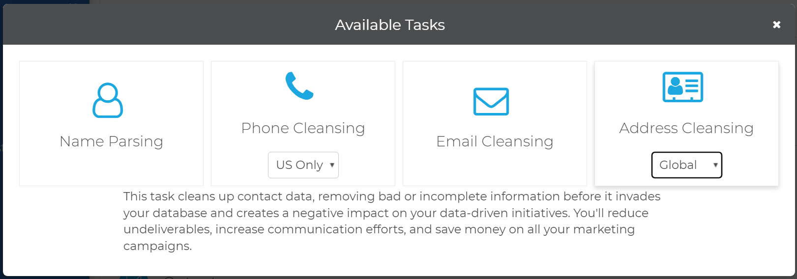
The Unison by Melissa Global Address Cleansing Task cleanses global contact data.
Input Fields
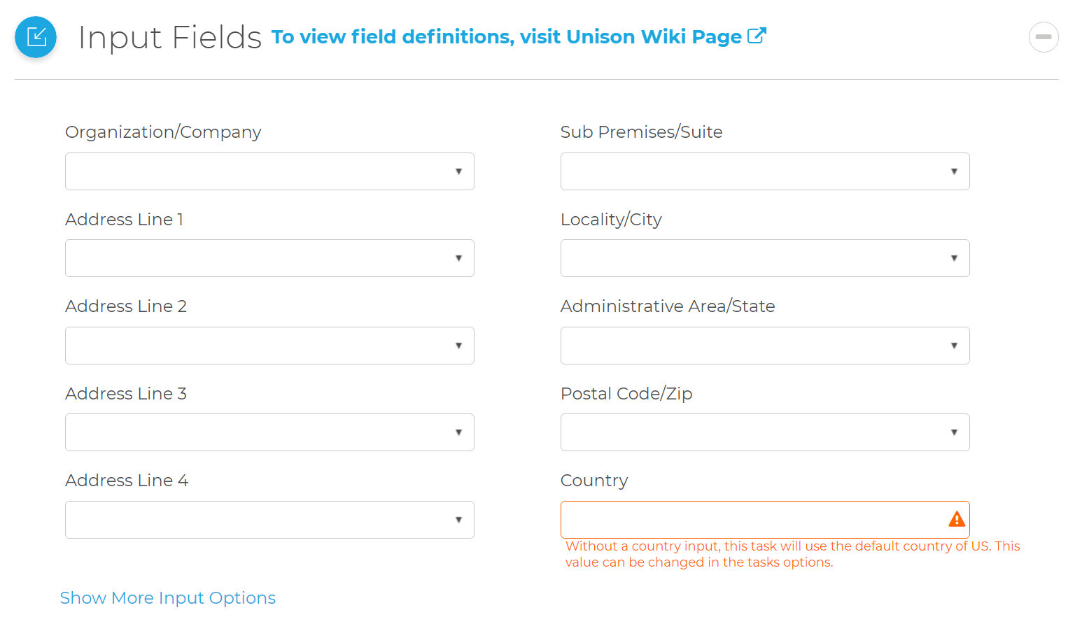
This section displays the possible inputs for the Global Address Cleansing Task. An address and Country are required.
Organization/Company
- The company or organization.
Address Line 1
- The first address line. This should contain the delivery address information (house number, thoroughfare, building, suite, etc.) but should not contain locality information (locality, administrative area, postal code, etc.) which have their own inputs.
Address Line 2 - Address Line 4
- This is optional. This should contain the delivery address information (house number, thoroughfare, building, suite, etc.) but should not contain locality information (locality, administrative area, postal code, etc.) which have their own inputs.
Sub-Premises/Suite
- The sub-premises or suite number.
Locality/City
- The locality name.
- US Term: City
- Canada Term: Municipality
Administrative Area/State
- The administrative area, state or province name.
Postal Code/Zip
- The Zip Code or Postal Code, depending on the country.
Country
- The country code. If this is not input, the country will default to the United States.
More Input Fields
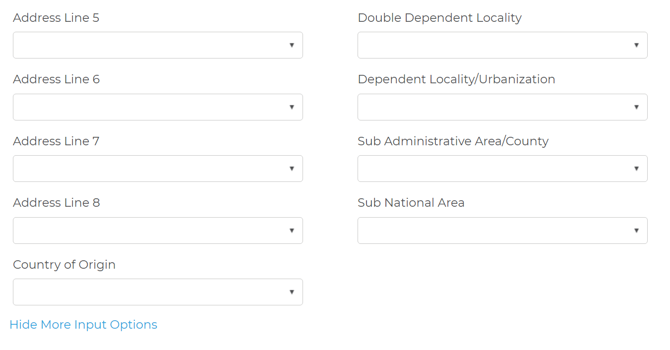
Address Line 5 - Address Line 8
- This is optional. This should contain the delivery address information (house number, thoroughfare, building, suite, etc.) but should not contain locality information (locality, administrative area, postal code, etc.) which have their own inputs.
Country of Origin
- This is used to determine whether or not to include the country name as the last line in Formatted Address.
- The destination country will be appended to the end of the formatted address when:
- Valid and different from the destination country.
- The destination country will not be appended to the end of the formatted address when:
- Blank or
- Invalid or
- Same as the destination country
Double Dependent Locality
- The smallest population center data element. This depends on the Locality and Dependent Locality fields.
Dependent Locality/Urbanization
- The smaller population center data element. This depends on the Locality element.
- US Term: Urbanization: In terms of US Addresses, this element applies only to Puerto Rican addresses. It is used to break ties when a ZIP Code™ is linked to multiple instances of the same address.
Sub Administrative Area/County
- The smallest geographic data element.
- US Term: County.
Sub National Area
- The administrative region within a country on an arbitrary level below that of the sovereign state.
Output Fields
This section displays the possible outputs for the Address Service. Select the on/off toggle to enable/disable the output of a field.
Organization
- The company or organization.
Address Line 1 - Address Line 8
- These will be the standardized or corrected contents of the input address. These lines will include the entire address including the locality, administrative area, and postal code.
Zip/Postal Code
- The postal code.
- US Term: ZIP Code.
Country
- The country name.
Latitude
- The latitude of the address.
Longitude
- The longitude of the address.
Dependent Locality
- A dependent locality is a logical area unit that is smaller than a locality but larger than a double dependent locality or thoroughfare. It can often be associated with a neighborhood or sector. Great Britain is an example of a country that uses double dependent locality. In the United States, this would correspond to Urbanization, which is used only in Puerto Rico.
- US Term: Urbanization.
Locality
- The most common geographic area and used by virtually all countries. This is usually the value that is written on a mailing label and referred to by terms like City, Town, Postal Town, etc.
- US Term: City
Administrative Area/State
- A common geographic area unit for larger countries.
- US Term: State
Delivery Line
- The delivery portion of the full address, from the sub-premise and house number to the street information. This does not include area information like doubledependent locality, dependent locality, locality, administrative area, and postal code if those values are available for the country.
Locality Line
- The locality information of the full address. This includes information such as doubledependent locality, dependent locality, locality, administrative area, and postal code if those values are available for the country. This does not include sub-premise and house number to the thoroughfare information.
Melissa Address Key (MAK)
- (MAK) A unique key assigned to an address record.
Melissa Address Key Base
- A unique key assigned to the base address of a complex with apartments or suites.
Address Type Code
- Returns a one-character code for the type of address coded. This element works only for US, Canadian, and Great Britain addresses.
- See Unison by Melissa Result Codes for a full list of result codes.
Formatted Address
- Returns the address in the correct format for mailing from the country specified in the Country Of Origin input. This includes the Organization as the first line, one or more lines in the origin country’s format, and the destination country (if required).
- The default separate line delimiter is a comma (
,), but can be changed under the Address Task Settings.
UPRN
- Great Britain Only. Returns the Unique Property Reference Number created and maintained by Ordnance Survey.
Result Codes
- Returned result codes for the address.
- For a list of result codes returned by Unison, see Unison Result Codes.
Additional Address Fields
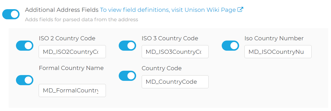
Adds fields for parsed data from the address.
ISO 2 Country Code
- The 2 letter ISO 3166 country code value.
- For example:
Country Code United States US Canada CA Philippines PH
ISO 3 Country Code
- The 3 letter ISO 3166 country code value.
- For example:
Country Code United States USA Canada CAN Philippines PHL
ISO Country Number
- The ISO 3166 country number value.
- For example:
Country Code United States 840 Canada 124 Philippines 608
Formal Country Name
- Official Name for the country.
Parsed Dependent Thoroughfare Fields
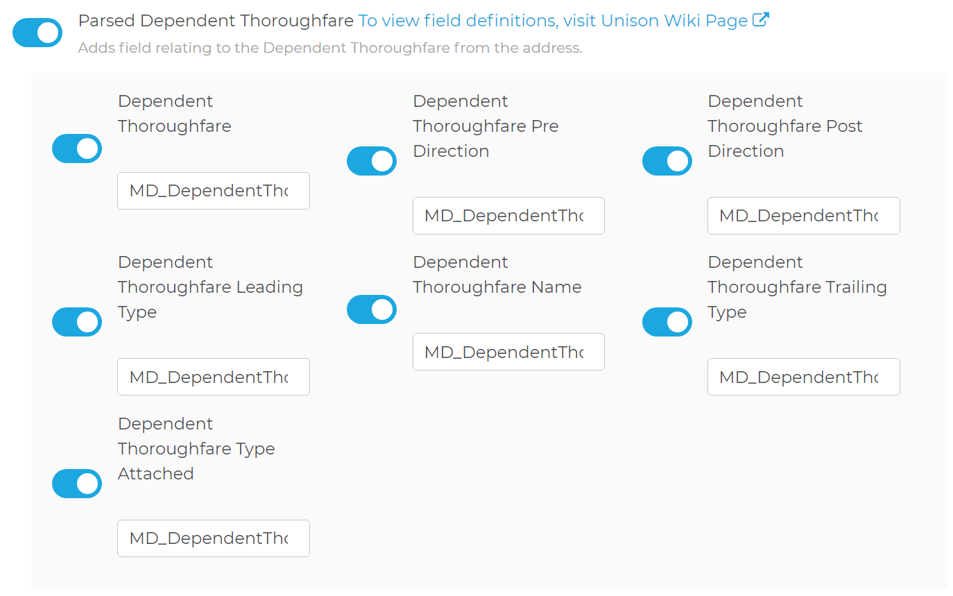
Adds fields relating to the Dependent Thoroughfare from the address.
Dependent Thoroughfare
- The dependent thoroughfare is a second thoroughfare that is required to narrow down the final address. This is rarely used.
Dependent Thoroughfare Pre Direction
- Pre Directions are directionals at the beginning of the dependent thoroughfare (i.e., N, S, E, W, NE, SW, etc.). This is a part of the Dependent Thoroughfare field.
Dependent Thoroughfare Post Direction
- Post Directions are directionals at the end of the dependent thoroughfare (i.e., N, S, E, W, NE, SW, etc.). This value is a part of the Dependent Thoroughfare field.
Dependent Thoroughfare Leading Type
- Leading Types are types at the beginning of the dependent thoroughfare (i.e., "Rue", etc.). This value is a part of the Dependent Thoroughfare field.
Dependent Thoroughfare Name
- The parsed Dependent Thoroughfare Name. This value is a part of the Dependent Thoroughfare field.
Dependent Thoroughfare Trailing Type
- Trailing Types are types at the end of the dependent thoroughfare (i.e., "St.", "Rd.", "Ave.", etc.). This value is a part of the Dependent Thoroughfare field.
Dependent Thoroughfare Type Attached
- The dependent thoroughfare type connected to the dependent thoroughfare name without a space. This is common in Germany. For example, "Berlinerstr." "str." stands for strasse and is the dependent thoroughfare type attached, while "Berliner" is the dependent thoroughfare name.
Parsed Regional Fields
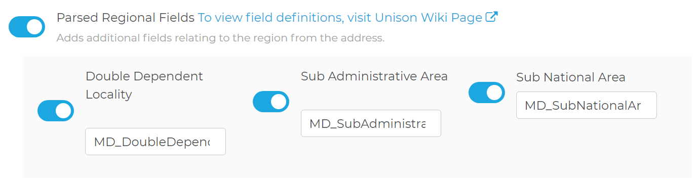
Adds additional fields relating to the region from the address.
Double Dependent Locality
- A logical area unit that is smaller than a dependent locality but bigger than a thoroughfare. This field is very rarely used. Great Britain is an example of a country that uses double dependent locality.
Sub Administrative Area
- A logical area that that is smaller than the administrative area but larger than a locality. While many countries can have a sub-administrative area value, it is very rarely used as part of an official address.
Sub National Area
- A logical area unit that is larger than an administrative area but smaller than the country itself. It is extremely rarely used.
Parsed Postal Facility Fields

Adds additional fields relating to the postal facility.
Post Box
- The parsed Post Box.
Post Office Location
- If available, this is the value that is associated to the location of the post office in relation to the address. This value may or may not be used in the official mailing address for the country in question. Currently, these are the countries we will return the data for: Serbia and Slovakia.
Country Description Serbia The Post Office Location field contains the old 5 digit postal number and name. The postal code field will contain the new 6 digit PAK number. Slovakia The Post Office Location field returns the name of the post office location if it is not the same as the delivery address locality.
Parsed Thoroughfare Fields
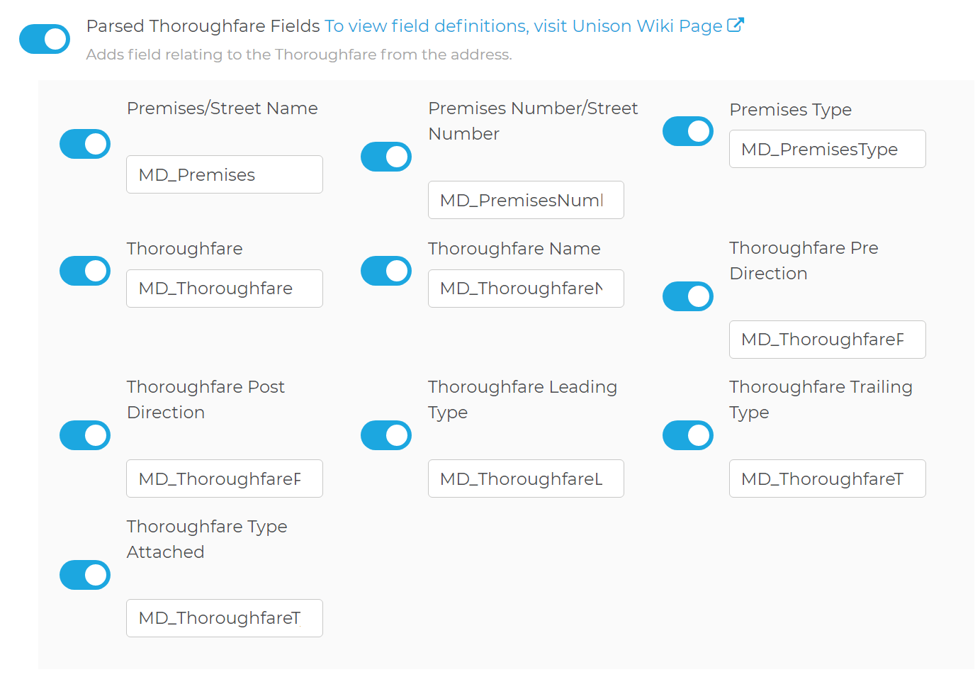
Adds fields relating to the Thoroughfare from the address.
Premises/Street Name
- The parsed premises name.
- US Term: Street Name
Premises Number/Street Number
- The parsed premises number.
- US Term: House Number
Premises Type
- The parsed premises type.
Thoroughfare
- A part of the address lines containing all the sub-elements of the thoroughfare like trailing type, thoroughfare name, pre direction, post direction, etc.
- US Term: Street
Thoroughfare Name
- The parsed thoroughfare name. This is part of the thoroughfare field.
Thoroughfare Pre Direction
- Pre Directions are directionals at the beginning of the thoroughfare (i.e., N, S, E, W, NE, SW, etc.). This is part of the thoroughfare field.
Thoroughfare Post Direction
- Post Directions are directionals at the end of the thoroughfare (i.e., N, S, E, W, NE, SW, etc.). This is part of the thoroughfare field.
Thoroughfare Leading Type
- Leading Types are thoroughfare types at the beginning of the thoroughfare (i.e., "Rue", etc.). This is part of the thoroughfare field.
- This term is not used in the US.
Thoroughfare Trailing Type
- Trailing Types are thoroughfare types at the end of the thoroughfare (i.e., "St.", "Rd.", "Ave.", etc.). This is part of the thoroughfare field.
Thoroughfare Type Attached
- The thoroughfare type connected to the thoroughfare name without a space. This is common in Germany. For example, "Berlinerstr." "str." stands for strasse and is the thoroughfare type attached, while "Berliner" is the thoroughfare name.
Parsed Subpremises Fields
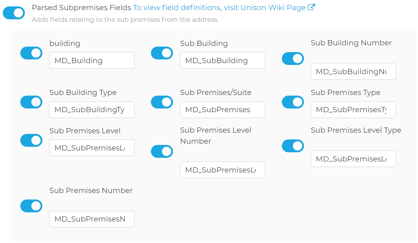
Adds fields relating to the sub premises from the address.
Building
- Descriptive name identifying an individual location. This is a string value that is the parsed Building element from the output.
Sub Building
- A smaller division of the building. For example, if an address has a building name that is a part of a larger set of buildings, then the sub building may be populated.
- Sub Building Number and Sub Building Type make up the parts of the Sub Building field.
Sub Building Number
- The parsed sub building number. This is part of the Sub Building field.
Sub Building Type
- The parsed sub building type. This is part of the Sub Building field.
Sub Premises/Suite
- Individual units with their own addresses inside a building. This is parsed from the Address Line 1 - Address Line 8 fields.
- Sub Premises Number and Sub Premises Type make up the parts of the Sub Premises/Suite field.
- US Term: Suite or Apartment
- For example:
- Sub Premises: Apt 25A
Sub Premises Type
- The parsed sub premises type from the Sub Premises/Suite field. This is part of the Sub Premises/Suite field.
- For example:
- Sub Premises: Apt 25A
- Sub Premises Type: Apt
Sub Premises Level
- A secondary piece of sub premise information used to describe a more generic division of the subpremise. For example, if you have an address like “1123 Market Way, Floor 12 Apt 25A” then the sub premises will be “Apt 25A” and the sub premise level will be “Floor 12”. This value is not widely used in official address data.
- Sub Premise Level Type and Sub Premise Level Number make up the parts of the Sub Premise Level field. In our example, the Sub Premise Level Type is “Floor” and the Sub Premise Level Number is “12”.
Sub Premises Level Number
- The parsed number from the sub premises level field. Sub Premise Level Type and Sub Premise Level Number make up the parts of the Sub Premise Level field.
- For example:
- Sub Premise Level: Floor 12
- Sub Premise Level Number: 12
Sub Premises Level Type
- The parsed type from the sub premises level field. Sub Premise Level Type and Sub Premise Level Number make up the parts of the Sub Premise Level field.
- For example:
- Sub Premise Level: Floor 12
- Sub Premise Level Type: Floor
Sub Premises Number
- The parsed number from the Sub Premises/Suite field. This is part of the Sub Premises/Suite field.
- For example:
- Sub Premises: Apt 25A
- Sub Premises Number: 25A
Extra Information Fields
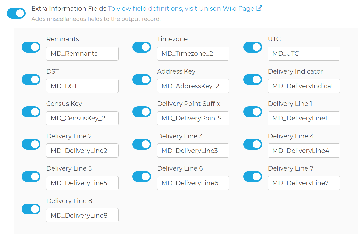
Adds miscellaneous fields to the output record.
Remnants
- Any elements parsed from the input address data which could not be processed or were not relevant to the address processing are returned in the remnant parameter.
Timezone
- Name of the timezone of the address.
UTC
- The Coordinated Universal Time number in format of UTC+#. Note that there are timezones that are not whole hours only, like UTC+9:30.
DST
- Returns a Y or a N based on if the country or area of the input observes daylight savings time. Note that the value returned by the UTC output does not change based on whether the country/area is currently in daylight savings time for not. We will only return the standard timezone and this flag to indicate is daylight savings is observed.
Address Key
- This is a country dependent field. The AddressKey can be used by other Melissa Data services, such as Geocoder or RBDI.
Country Description US This returns a 11 digit code representing the combination of the zip code, the plus4, and the delivery point. This is a fairly good representation of a unique US address and often used as the core of postal barcode. However, this code is not guaranteed to be unique to an individual address, please use the Melissa Address Key field instead for that purpose. It is possible that this field is empty or not 11 digits if the address is a Non-USPS address (link to something about non-usps addresses). GB This field returns the UDPRN, which stands for Unique Delivery Point Reference Number. It is an 8 character code that is assigned and maintained by Royal Mail to each delivery point address. AU This returns the DPID (Delivery Point ID). This is a 8 digit number that identifies a mailbox according to Australia Post.
Delivery Indicator
- Returns a one character code that indicates if the address type. It is not available for all countries. Currently, this field is available for the US, GB, NL and IE with more countries planned in the future.
Code Address Type R Residence B Business U Unknown
Census Key
- This is a country dependent field. It is designed to return a code that correspond to the census division information for a country. Currently, this field is only returned for the US.
- US: The CensusKey for the US is a 15 or 16 digit code that is made up of the following components: FIPS Code, Census Tract, Census Block, and CensusBlockGroup if it exists.
Delivery Point Suffix
- This is a country dependent field. This field returns an identifier that represents a suffix code usually tied to a delivery point.
Country Description GB This is a 2 character (first is numerical, 2nd character is alphabetic) that is assigned by Royal Mail. When added to the postal code, this allows each live delivery point to be uniquely identified.
Delivery Line 1 - Delivery Line 8
- These return the Address Line 1 - Address Line 8 fields containing just the street address and dependent locality. They will not contain locality, administrative area, postal code etc.